Heat wave from Saturday with temperatures up to 40°C
Temperature rises gradually from Thursday 6 August 2026, and from Saturday 8 August a three-day heat wave is expected with values touching 40 degrees. At the same time, high fire risk is in effect for the Peloponnese, Preveza and the Municipality of Delphi.
English Machine-translated from Greek · Read the Greek original
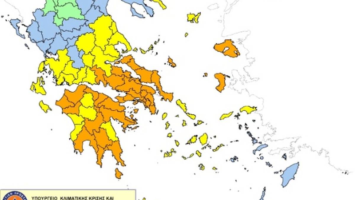
A gradual rise in temperature is expected across the country on Thursday 6 August 2026. The forecast calls for sunshine with few clouds, increasing during the warm hours over mountainous inland areas, while isolated showers are possible in the mountains of Epirus and Macedonia. Temperature ranges from 27 to 35 degrees Celsius, with readings two to three degrees lower in the north and east. Winds will continue from northerly directions at 3 to 5 Beaufort, reaching 6 in the Aegean and locally reaching 7 Beaufort at times. From Saturday 8 August a three-day heat wave is expected, with temperatures touching 40 degrees.
Theodoros Kolydas, director of the National Meteorological Service, describes a “hotter phase peaking 8 to 10 August,” with the phenomenon more pronounced over central and northern mainland areas. Forecast models give indicative maximum values of 40.5 degrees in Lamia, 38.8 in Larissa, 38.8 in Thessaloniki, 37.4 in Patras and 36.9 in Athens. He explicitly cautions, however, that fifteen-day forecasts reflect a trend rather than precise daily conditions. That is, this is a forecast, not a measurement: the figures may change as the three-day period approaches and the exact distribution of maximum values per region will be finalized by subsequent briefings from the service.
The rise is expected to be more pronounced in Thessaly, Phthiotis and areas of Macedonia—the inland basins where the absence of sea influence allows mercury to climb higher than in coastal and island areas. In parallel, the Daily Fire Danger Forecast Map issued by the General Secretariat of Civil Protection shows category 3 (high risk) for Thursday 6 August for the Peloponnese region, the Preveza Regional Unit and the Municipality of Delphi. At the top level, category 4, are Attica, Boeotia and Euboea. In Preveza, a traffic ban is in effect from sunset to 06:00 the next day in forests and other high-risk areas.
Citizens are urged to avoid burning dry grass and branches, using equipment that produces sparks, outdoor grilling, bee-smoking and discarding lit cigarettes, while every fire must be reported immediately to the Fire Service at 199 or to 112. The combination of high temperatures, low relative humidity and strong northerly winds constitutes the classic mix that transforms a small fire into a major front in minutes, as shown by the major fire in Boeotia that started from sparks of a wind-park network, but also by the toll of 28 agricultural and forest fires in a single twenty-four hours. The critical period is placed from Saturday 8 to Monday 10 August, when updated regional risk maps are also expected to be released.
Greece news in 1 minute
Greece news in 1 minute
Sources
Primary sources
- Weather: Temperature rising, strong winds continuing — three-day heat wave with 40°C from Saturday — NewsIT · published2026-08-06 · retrieved2026-08-06What it says: Η πρόγνωση της Πέμπτης 6 Αυγούστου, οι άνεμοι και το τριήμερο κύμα ζέστης από το Σάββατο 8 Αυγούστου.
Official announcements
- Theodoros Kolydas on the weather: Hottest phase approaching — iefimerida · published2026-08-06 · retrieved2026-08-06What it says: Η τοποθέτηση του διευθυντή της ΕΜΥ για τη θερμότερη φάση που κορυφώνεται 8 έως 10 Αυγούστου και η επιφύλαξη για τις δεκαπενθήμερες προγνώσεις.
- High-alert fire-risk bulletin for Preveza Regional Unit on Thursday 06.08.2026 — atpreveza.gr · published2026-08-06 · retrieved2026-08-06What it says: Η κατηγορία κινδύνου 3 για την Π.Ε. Πρέβεζας, η απαγόρευση κυκλοφορίας και οι οδηγίες αυτοπροστασίας.
Media
- Weather — Kolydas: Three days of heat from Saturday with temperatures reaching 40 degrees Celsius — thebest.gr · published2026-08-06 · retrieved2026-08-06What it says: Οι ενδεικτικές μέγιστες τιμές των προγνωστικών μοντέλων ανά πόλη και οι περιοχές με την εντονότερη άνοδο.
This text was written with the use of artificial intelligence, based on the sources above.